Commerce launches statewide Washington State Zoning Atlas to support smarter planning
First-of-its-kind tool translates local zoning into standardized categories for easy comparison
OLYMPIA, Wash. – Understanding how zoning shapes communities across Washington is now a little easier thanks to a joint effort from the Washington State Department of Commerce’s Growth Management Services unit, MAKERS architecture and urban design, BHC Consultants, and students from all four of the state’s accredited planning programs.

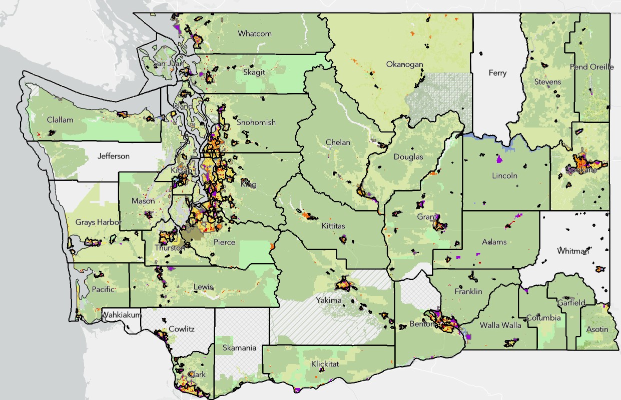
A statewide view of the Washington State Zoning Atlas, which compiles zoning data from local jurisdictions into standardized categories for easy comparison.
Commerce recently launched the Washington State Zoning Atlas (WAZA), a first-of-its-kind tool to compare zoning data from across the state in one standardized, interactive platform. The Washington State Zoning Atlas is available as an interactive web-based map and downloadable database.
In Washington, cities and counties have the power to write and manage their own zoning rules within the framework of the state’s Growth Management Act. While this local control gives communities flexibility, it also means there is no standard way to publish or organize zoning codes. This makes it difficult to compare zoning information across the state. The WAZA changes that. It’s the first statewide tool to translate local zoning codes into consistent categories, which means more consistent zoning will be possible for housing, businesses and other development types.
“The Washington State Zoning Atlas is a powerful resource to answer big questions and help bring more housing online,” said Commerce Director Joe Nguyễn. “Zoning decisions shape what kinds of homes get built, where they’re built, and who can afford to live there. Local governments make the rules that decide what gets built where, but until now we didn’t have a clear picture of how those rules add up statewide.”
The WAZA is especially valuable for examining where barriers to housing may exist and how new housing laws, such as middle housing or minimum parking requirements, apply and are being implemented across the state. It also supports environmental, ecological and economic research by clarifying where development is likely to happen and how intensive it may be. A WAZA user guide and examples of how WAZA can support research and policy analysis across different land use scenarios are also available.
“What the Zoning Atlas does and what it’s really beneficial for is showing trends and showing relationships between jurisdictions,” said Justin Patterson, a Pierce County planner and Master of Urban Planning and Design student at the University of Washington Tacoma. “The use case of having that visually in one place where you can see how your jurisdiction is kind of lining up on a regional scale and how things are changing across jurisdictions. There’s a lot of value in that to local jurisdictions.”
UW Seattle, Western Washington University and Eastern Washington University have accredited planning programs. Students from those three universities and students from UW Tacoma worked together in a first-ever joint course to learn about zoning in Washington and test methods of collecting data to build the WAZA.
“The Zoning Atlas fills a significant information gap that has limited our ability to see how policies are implemented on large scales,” said Dave Andersen, managing director of Growth Management Services. “Now we have a foundation to see the big picture that will allow us to make better informed decisions.”
Tammy Laninga, associate professor at WWU’s College of the Environment, led the cross-university course and said students got hands-on experience working on the kinds of planning problems they will face in their careers.
“What was so interesting was how every community’s code had something kind of unique about it. The students learned very quickly that zoning gets really complicated,” Laninga said. “Like, how do you go from hundreds of unique zoning codes to something that is semi-standardized? That was the challenge and that was what the class helped with. By the time the class was over, we had a really solid protocol and a solid way forward.”
Despite the benefits WAZA provides, zoning remains local as cities and counties continue to update their zoning codes and maps regularly. The WAZA reflects data collected and standardized by Commerce and our partners from April 2024 to June 2025. Some local zoning codes have already changed since this data was gathered. Commerce plans to update the WAZA periodically pending the availability of funding to continue this work.
Legal Disclaimer:
EIN Presswire provides this news content "as is" without warranty of any kind. We do not accept any responsibility or liability for the accuracy, content, images, videos, licenses, completeness, legality, or reliability of the information contained in this article. If you have any complaints or copyright issues related to this article, kindly contact the author above.
